


Book Tickets Online
About
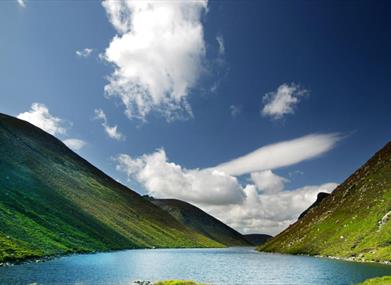
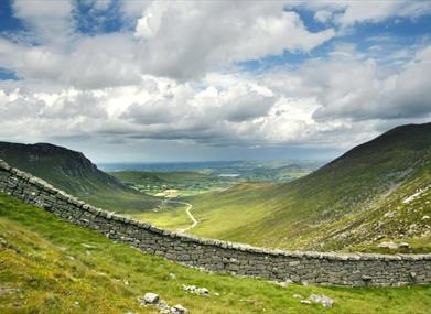
The Mourne Mountains, a stunning range in County Down, Northern Ireland, boast twelve imposing summits that rise dramatically to over 2,000 feet. Dominated by Slieve Donard, Northern Ireland's highest peak, this area of outstanding natural beauty is a haven for outdoor enthusiasts.
Partially owned by the National Trust, the Mournes offer a diverse landscape, from challenging hikes to scenic drives. The iconic Mourne Wall, a remarkable feat of engineering, snakes across 15 peaks, a testament to the region's rich history.
Whether you're seeking a leisurely stroll or a strenuous climb, the Mournes cater to all abilities. Enjoy breathtaking panoramic views, explore ancient woodlands, or simply immerse yourself in the tranquility of this natural wonderland. With the Mourne Coastal Drive winding along the stunning coastline and the High Mournes Scenic Loop offering a glimpse into the heart of the mountains, there's something for everyone.
For those eager to conquer Slieve Donard, the highest point in Northern Ireland, expect a challenging yet rewarding ascent. Allow approximately 4-6 hours for this hike, depending on fitness levels.
Where can I find a route map for the Mourne Moutains?
Maps and guides are available to purchase in the Newcastle Visitor Information Centre
Also check out the following online guides, provided by Visit Mourne:
- Mourne Mountains; A Walkers Guide
How long does it take to climb the Mourne Mountains?
Individual mountains can be climbed in a single day, although many walking challenges incorporate multiple peaks covered in one day, or multiple days with camping overnight as part of the adventure. The highest peak, Slieve Donard (853m), can be completed within 4-6 hours depending on ability level (starting and ending in the Donard car park, in Newcastle).
Which are the tallest peaks in the Mournes?
The tallest mountains within the Mournes include Slieve Donard (853m), Slieve Bearnagh (739m), Slieve Commedagh (767m), Slieve Binnian (747m), Slieve Meelbeg (708m) and Slieve Meelmore (682m). They all have fantastic views from their peaks, but on a clear day, the view from Slieve Donard cant be beaten, taking in the rest of the mountain range, the rural countryside below and the Irish Sea, sometimes as far out as the Isle of Man and Scottish coastline.
Are the Mourne Mountains worth visiting?
For those who enjoy engaging with nature and the outdoors, walking and hiking and spectacular views, the Mountains of Mourne are well worth visiting. Their proximity to the coast and rural countryside provide a wealth of forest parks and seaside walks, with some of our top recommendations included in our Mournes Highlights.
Mountain Safety
Remember to prioritise safety when exploring the Mournes. The Mourne Mountain Rescue Team provides invaluable support to those in need.and this service is provided by a group of volunteers who are based in Newcastle, at the foot of Slieve Donard. They work together with the statutory agencies in the area, including the PSNI, Coastguard, Northern Ireland Ambulance Service and The Hazardous Area Respnse Team. Please refer to their safety advice before walking or hiking in the Mountains.
Book Tickets
Facilities
Establishment Features
- Accommodation nearby
- Guided Tours Available
- Route maps available
- Visitor information - Newcastle Visitor Information Centre 10-14 Central Promenade, BT33 0AA Tel 03301374046
Leisure Facilities
- Outdoor activities
Parking & Transport
- Car parking
- Coach parking
Provider Preferences
- Outdoor Attraction


